| Home | Next Gig | Programme | Special Events | About PJC | Links |
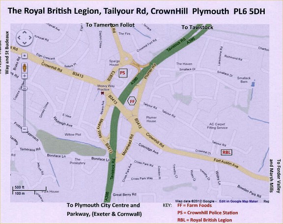
From The (A38)Parkway. East or Westbound
Leave at Manadon Junction and follow the signs for Tavistock, A386 and follow green then red directions
(From Plymouth City Centre, cross Manadon Flyover on Tavistock Road and follow remaining green then red directions)
After about 1/2 mile, pass under Crownhill flyover and turn left immediately after.
Stay in the left lane and turn left at the roundabout, pass Crownhill Police Station on the left and join the slip road onto Crownhill Road, passing over the road you just came along. Then follow red directions.
(From Crownhill Road and West Plymouth, follow remaining red directions.)
Turn left round the Farm Foods car park into Plumer Road and turn immediately right opposite Farm Foods car park entrance into Tailyour Road. Royal British Legion is 1/4 mile on the right, immediately after the Child Support Agency.
From Tavistock and North Plymouth
From Derriford roundabout follow signs for City Centre (A386) for about 1/2 mile passing B&Q and McDonalds on the right and through two sets of traffic lights. Over the brow of the hill, pass the Safety Camera (40)mph) on the central reservation and keep left (careful of the bus lane!) onto the slip road (Plumer Road) just before Crownhill Flyover then turn left opposite Farm Foods car park entrance (before the end of the slip road) into Tailyour Road. The Royal British Legion is 1/4 mile on the right, immediately after the Child Support Agency.
There are bus stops In Fort Austin Avenue near the RBL and the Junction with Widey Lane with pedestrian access (but NO vehicle access) to the RBL car park.